Wednesday, September 21, 2011

The Rain in Spain...


Yesterday I headed to the Spanish Peaks Wilderness in the hope of getting some nice sunset photos of West Spanish Peak. It's a fairly simple matter when the weather cooperates — just find your way to Cordova Pass, and about 100 yards from the trailhead you're looking through the trees at the peak. I planned on making it only slightly more difficult by walking a little farther up the trail, where the trees give way to rolling meadows where I once saw a black bear amble across the trail right in front of me in broad daylight. No bear sightings on this trip, but not really much in the way of sunset light either. The photo above shows why. [click to enlarge] Rain clouds and the occasional clap of thunder kept me on my toes while I waited to see if the sun would sneak out from under the gray mass over Trinchera Peak to the west. No go. Oh well, it was a day in the mountains. And like I often say, a bad day in the mountains is better than a good day most anyplace else.

Saturday, September 17, 2011

Close, But No Cigar!


This morning I peeked outside before sunrise and noticed some lingering fog in the area, so I grabbed my camera gear and headed to Garden of the Gods. I almost T-boned an S.U.V. on the way there when the driver apparently was still asleep and ran a red light. But that's not the close call I'm writing about.

I got to the Mesa overlook an hour or so before sunrise and there was a perfect band of fog stretching along the Front Range between the rock formations in the Garden and Pikes Peak. If it would've stayed in that position, I would've had an epic morning of photography. But no, it didn't. A breeze from the north pushed it south of the Garden, and by the time there was enough light to shoot, only the trailing edge was still within view of any compositions that included the park. Oh well, it was still a spectacular morning. This week's massive storm event (five inches of rain in Colorado Springs in 24 hours? Wow!) left a dusting of powdered sugar on Pikes Peak's tundra, and it has so far hung on. With the first day of autumn next week, maybe the snow is here to stay til next spring. We shall see! [click photos to enlarge]

R.I.P.


A week ago an experienced climber fell to his death near Pyramid Peak, on a sub-peak called Thunder Pyramid. My thoughts go out to his family and friends who are mourning the loss. (I'll refrain from naming him, since I didn't know him, and only read of the incident in the Aspen Times a few days ago.)

In our book 14,000 Feet – A Celebration of Colorado's Highest Mountains, Walt Borneman came up with the perfect title for the chapter on the Elk Mountains, of which Pyramid Peak is part – Red, Rugged & Rotten. The rock that makes up these imposing mountains – including the familiar and beautiful Maroon Bells, just across the valley from the Pyramid Peak massif – is the kind that you can pick up in your hands and twist the sedimentary layers apart. Many people have died climbing these peaks, and as last weekend's incident shows, you don't have to be an inexperienced hiker in over your head to lose your life up there.

Then again, it doesn't take a red, rugged or rotten mountain to cause the death of a climber. Even the easiest fourteeners can turn on you when the weather moves in quick and/or unexpectedly. It's often said by those who climb Colorado's mountains that it's best to turn back if things get dicey, with the sound knowledge that the summit will be there next time. Still, when you've hiked since sunrise to get to the top of a mountain so you can check it off your list (not my reason for exploring Colorado's high country!), having the summit within sight can be too tempting. But that lure can be fatal. Mother Nature couldn't care less how many peaks you've got to go on your list.

This is a photo of clouds breaking around a sub-peak of Pyramid Peak, taken Thursday afternoon as a rough-and-tumble storm system began to ease its grip on Colorado. [click to enlarge]

Wednesday, September 14, 2011

Payback!

This summer I moved out of the tiny apartment I had lived in since my divorce and move from Pueblo to Colorado Springs, into a house that ironically was one street over and two houses down from the very first house our family lived in when we moved from suburban Chicago. It's a nice, established neighborhood. Even so, I awoke last week to the news that my truck's driver's side had been pelted with eggs the night before. It's not a reflection on the neighborhood, it can happen anywhere, especially since I typically park my truck on the street.

I dragged the hose to the front yard and hooked it up, and started spraying the mess off my ride. About halfway through the task I started cracking up. It suddenly dawned on me that, way back in my teen years in this very same neighborhood, I had been guilty of the same prank. My mom had befriended a woman down on her luck, and she and her son, Dieter, stayed with us briefly.

To put it mildly, Dieter was a bad influence. In the short time we hung out, we caused quite a bit of mayhem in the neighborhood. There was one of those traveling carnivals parked in the Rustic Hills Mall parking lot, and after carousing there one night, we came home and grabbed a carton of eggs, some maple syrup and various other ingredients, then proceeded to leave our mark on many parked cars nearby. We capped off our devious misdeeds by standing on the back porch and lobbing eggs at the back of the house behind ours, which we successfully blamed on my older brother, Steve, when the neighbor misjudged the time of the incident when recounting it to our mothers the next day. We couldn't have possibly done this, we posited, because we were still at the carnival at that time! But, boy-oh-boy, did we look like the bigger "men" when we graciously agreed to help the neighbor clean up the mess. In hindsight I'm pretty sure he knew we were the culprits, but at the time we thought we had pulled a fast one.

On a daylight return to the carnival the next day, Dieter hauled off and punched some kid I vaguely knew in the stomach and kept on walking. On the walk home, a car came screeching to a halt in front of us, and out popped this kid and his dad. Pops was there for vengeance, and he socked me in the stomach! He then held the much larger and slightly older Dieter's arms back and instructed his son to take revenge, which Dieter somehow managed to talk his way out of. Apparently, hanging out with such a bad seed can be hazardous to one's health! I'm just lucky Dieter's visit lasted just a few days.

Consolation Prize


After my nearly fruitless 500-mile trip to Monument Valley on Sunday, I decided against hanging around for another day to try to get my Mitten shadow shot on Monday, and headed back to Colorado Sunday night for a shot at an interesting sunrise Monday morning. I pulled into the upper trailhead parking area on Lizard Head Pass a little before midnight, dropped Tears for Fears' excellent "Seeds of Love" CD in, cranked the stereo and drifted off to sleep. As usually happens, I woke up several times to enjoy different parts of the disc as it cycled through several playings, finally turning off the music at around 5am. At 5:30 my alarm jolted me awake. No biggie, I figured I could grab a nap along the road on the long drive home.

It rained steadily all night long, finally letting up sometime in that uninterrupted 30-minute window of sleep I enjoyed. As is usually the case with overnight rain, I was pretty sure I'd awake to find some fog drifting through the valleys. The problem was deciding where to go. In the San Juan Mountains around Telluride, there are lots of options. I headed down the road towards Ophir, but the fog wasn't as prominent below the San Miguel Mountains as I'd hoped. I made a spur-of-the-moment decision to head over Ophir Pass, a rocky four-wheel-drive road that drops out on Highway 550 near Silverton on the other side. As I got to the top of the pass, sunrise was at hand. As I headed over to the east side, the sun found a hole in the clouds and lit the tundra with incredibly rich tones. [photo #1 - click to enlarge] In early September the tundra up above treeline is well on its way to fall colors, and the warm light only added to the colorful palette. I also got my first glimpse of peaks around the pass, and what had been rain at lower elevations had been snow up higher — another sign of fall in the Colorado high country.

I noticed that the low clouds and fog I was after was farther down the valley towards Silverton, so I continued on. Once I got to the highway, I hung a left and headed towards Red Mountain Pass, where the clouds had taken up residence. Once on the pass I was still in the gray soup, so I took a left on the rough Black Bear Pass road, which climbs steeply from Red Mountain Pass, and was soon successfully above the clouds. The scene was even better than I'd hoped for, with Bear Mountain and Grand Turk to the south capped with fresh snow and clouds drifting in and out of valleys both near and far. [photo #2 - click to enlarge] Figuring that no one would be coming up or down the narrow road at this early hour, I parked on an uphill grade with a great view and set up my tripod. I could've shot from that spot for a long time, but thought maybe I should get up a little higher, to see what the expanded view would offer. I turned the ignition key in my truck and nothing happened. Oh crap! My mind immediately started envisioning backing down the narrow road with no power steering or power brakes. My heart raced. I turned the key several more times, and finally the engine fired, resetting my clock and spitting out my CD at the same time. Hmm, maybe I need to rethink those all-night CD rock shows I have a habit of enjoying!

With the possibility of getting stranded by a dead battery, I scrapped my plans to head home via four-wheel-drive Cinnamon Pass and Lake City to check on the status of fall colors along Highway-149 and made a commitment to stick to paved roads all the way home, making sure to leave the engine running. So much for catching a nap on the way home! But I was thankful that, after not getting the shot I had envisioned in Monument Valley the night before, I got something photographically worthwhile out of the trip.

Tuesday, September 13, 2011

A Long & Winding Road to Little Effect


A few times a year there's an interesting shadow play that takes place in Monument Valley (that familiar place on the Utah/Arizona border where John Ford made all those great John Wayne westerns). The sun sets in such a position that it casts the shadow of one of the Mitten Buttes on the other. It's a scene I've long wanted to photograph, and happens around my birthday each year. (And again roughly six months later.) Well, I decided that the possibility of combining the Monument Valley Mitten Butte shadow with this year's perfectly timed moonrise was just too good to pass up, so I made a banzai drive down there Sunday. I totally misjudged the time it would take to get there from Colorado Springs, and even leaving at 10am, I got to Monument Valley at 6:40pm, only 20 minutes before moonrise. Phew! Close call! It was killing me going through the San Juans in southwest Colorado with clouds hanging all over the place and lots of stormy weather all around, but I was so determined to get to MV in time that even if Elvis riding a unicorn had crossed Highway 145 right in front of me, I would've kept on truckin'. Didn't really matter, since the moon was a little farther right than I had thought it would be, just left of Merrick Butte, and there were thick, lightning-spitting clouds all around that prevented the infamous shadow scene from appearing. Oh well. I tried to get some lightning shots, because it was popping off all over the place, but failed in that attempt. This is just about the only scene I came away with for my 500 miles of trouble. As always, click the image to see a larger version.

Sunday, July 10, 2011

Chasin' Rainbows


Over the weekend I car-camped up above North Fork Reservoir in the southern Sawatch Range near Salida. As sunset approached, I was heading down to nearby Billings Lake to try for some sunset reflection photos of the surrounding peaks. Looking over towards Pomeroy Peak, I noted that the late-day sun was backlighting a bright orange curtain of rain that looked like it was headed in my direction. I hoofed it down to the lake, thinking that if it was as brief a shower as I suspected, maybe I'd get a rainbow reflected in the lake.

The wind blew so hard that there was no chance of a reflection on the choppy surface of the lake, but sure enough, a rainbow appeared over the shoulder of Calico Mountain, just as sunset alpenglow light turned the already reddish peak to a brilliant, warm glow. In this case, half right was right enough.

Sunday, July 3, 2011

Nature's Gift


I'm currently in the midst of a photo trip over the Fourth of July holiday, and yesterday I was rewarded with what can only be described as a gift from nature. I left my truck at 11am, with the intention of climbing North Star Mountain near Breckenridge. If conditions warranted, my plan was to stay til sunset and hike out in the dark.

North Star Mountain sits at the junction of the Tenmile Range to the north and the Mosquito Range to the south. From atop the peak the view takes in close-up views of a few of Colorado's fourteeners — Quandary Peak to the north and Mounts Lincoln, Bross and Democrat to the south. Not that the fourteeners are the only attraction. The headwall to the west of Quandary is an array of craggy peaks, and after the epic snow season that just ended, the basins below North Star are still choked with snow.

Being in less than tiptop shape, I took my time getting up the peak. The weather was nothing short of perfect, with puffy white clouds drifting overhead, and nary a hint of dangerous lightning storms to prevent my plan to stay on the summit ridge all day. I stopped just a hundred feet shy of the summit, due to some dangerous-looking snow cornices between me and the final pitch, but it didn't matter. The view in every direction was astounding! With many hours to go til sunset, I bided my time taking it all in, trying to stay out of the occasional stiff wind by hiding out amongst the rocks.

Well, sometimes the best laid plans can go awry. All those docile clouds that had delighted me all day began to fizzle, and one lone, dark mass of clouds to the west began to form. It wasn't bad weather I was concerned with, as it didn't really look like the type of cloud to produce lightning. I was more concerned with the possibility of hiking all that way, staying up there all those hours, and then being shut out for sunset color. I watched this cloud build for an hour, and sure enough, when the sun dipped low to the horizon, it sank into the gray morass. So much for that!

I figured the sun might peak up underneath the clouds after sunset and give me a show, but I had had enough. I began the trek back to the truck a bit before official sunset time, figuring a little extra light might be nice. I followed a sketchy trail through the rocks down North Star's east ridge as the light faded fast.

And then I got a surprise. A fox darted across the trail in front of me. To be honest, it scared the crap out of me! It seemed habituated to humans enough that I was able to sit down, change lenses, and spend almost half an hour taking pictures of it. The lighting conditions were far from ideal, so I had to bump the ISO on my camera up fairly high to capture pictures in the low light, but after being thwarted in my sunset attempts back up the ridge, finding this willing subject at 13,000 feet after thinking my day was a bust saved the day.

Wednesday, April 6, 2011

Deep Blue, Too


After Monday's crescent moon hunt, I decided to go out to Garden of the Gods last night for a repeat performance. This photo is one of many results. Again, no trickery to get the detail in the dark side of the moon, that's completely a product of Earthshine.

Monday, April 4, 2011

Deep Blue


There was an awesome wave cloud over the Front Range this afternoon, but it never really lit up at sunset. After sunset, I was heading home from running around, and noticed the thinnest of crescent moons sandwiched between Blodgett Peak and the trailing edge of the wave cloud. By the time I got home and grabbed my camera and tripod, the cloud had advanced far enough east that including it in the image was impractical. This simplistic approach was the end result. Keep in mind that even the relatively short, 3.2-second exposure at 200mm showed movement in the moon, making the crescent about double its size. To the naked eye it was barely discernible.

[no Photoshop magic was used to enhance the incredible amount of Earthshine you see here.]

Drive-Thru for a Laugh

Or should we cry?

Yesterday at the drive-thru window of my nearby Sonic:

Blonde Teen Cashier: "That's $2.34."
Me: [hand her $3.04]
BTC: [a look of horror on her face, calls one of her co-workers over, who promptly blows her off. Second co-worker does the same. They're busy. BTC fumbles for some change, and I notice at least one penny entering into the mix.]
Me: [as she hands me my change] "Is there a penny in there?"
BTC: "Yes."
Me: "You're not good at math, are you?"
BTC: "No. That's why I work at Sonic."

This morning, same drive-thru, same BTC working the window:

BTC: "Oh, it's Change Guy!" [funny, she doesn't seem happy to see me...]
Me: "Yeah, but I'll make it easier for you today." [hand her $3.06 for a $2.56 bill...]
BTC: [lays my coins on the counter, rummages through her fanny pack for her cell phone, starts punching numbers into its calculator function.
Me: [laughing hysterically on the inside]
BTC: Is this right? [hands me a nickel]
Me: "Um, no."

This afternoon, same drive-thru, same BTC working the window:

BTC: "It's Change Guy!" [even less enthusiastic about seeing me this time.]
Me: "Yeah, but I'm gonna make it really easy for you this time." [hand her a twenty for a $2.34 bill...]
BTC: [ah yes, the return of Mr. Cell Phone Calculator!] "Here's your change."
Me: "You don't mind if I count it, do you?"
BTC: "Nope!"
Me: "Good job, you got it right!"
BTC: "Here's your drinks." [drinks? hands me one drink, then begins to hand me a second one of equal size.]
Me: "You realize I only ordered one drink, right?"
BTC: "Oh, I read the ticket wrong."

How much you want to bet she's a straight-A student in school?

Friday, April 1, 2011

Awesome, Even When In Hiding


Earlier this week I took advantage of low clouds over Colorado Springs and headed up Rampart Range Road for sunrise. Once I cleared the lower cloud deck, my chances of catching sunrise light on Pikes Peak were dashed by the vigorous storm clinging to the mountain's alpine environs. But you know what? Even when you can't even see the mountain, it's an awesome thing to behold. [top] Besides, when Pikes Peak is hiding, I can just train my camera on other nearby subjects, like Almagre Mountain [middle] and little details in the forest below. [bottom]

As always, click each photo to enlarge.

Sunday, March 27, 2011

Frasier, Niles & Martin


The Cranes! (groan...)

Did a quick overnighter to the San Luis Valley a few days ago to photograph the bi-annual migration of sandhill cranes to the Monte Vista National Wildlife Refuge. Last year was the first time for me down there, and this year there were many, many more birds. I lucked out with the timing. Didn't really come away with a deep and wide body of work from the trip, as it was sort of discombobulating with so much action happening so quickly in every direction. It didn't help matters much that I car camped nearby that night, and spent too much time listening to music and not much time sleeping. When morning arrived, I was in no mental shape to be a productive member of photographic society! Oh well, there's always next year.

[as always, click on the images for larger versions...]

Tuesday, February 22, 2011

Riley the Wonder Dog


Someone pointed out to me recently that I mention my dog, Riley, in the subhead of this blog, but I have yet to mention him in any of my posts. That ends TODAY! Here, for your viewing pleasure, is Riley at his best, via Youtube: http://www.youtube.com/watch?v=halLJmRtbSY

Riley lives at my ex-wife's house, but we share custody in a completely amicable way. I go over to her house most every weekday to let him out while she's at work, and he occasionally spends time with me at my place, although without a yard, it makes it a little tougher. Since the above video was made, Riley has acquired a sister, so he no longer has to play tug-of-war by himself. Sindy is an absolutely perfect match for Riley in both size and temperament. They can really tear across the back yard, and then take turns wrestling each other to the ground. Good times!

Wednesday, January 5, 2011

Complaint Department

Just received in my in-box (emphasis added):

Hello,

I ordered a 2011 Scenic UTAH Calendar by Tom Till as I do every year.

I was disappointed because over the last many years you have included October 16th as National Boss's Day. This year you did not. Why?

I think the numbering system you used this year (font) and size is not as good as last year. My question is why can't you simply include all the holidays you used from last year. [sic]

I am not disappointed in the work by Tom Till, but I am with the holiday and layout. Maybe next year your publishing company can get it right.

Just wanted you to know someone is paying attention out there and your quality control may be a little bit off.

Thank you.
(I'll show mercy and not publish her name.)

And my response:


Hi _________,

Thanks for your concern. Speaking of getting things right, our company has been publishing Tom's calendar for several years, and we have never included National Boss's Day. Just as in the calendar titles we've published for nearly 20 years, the only holidays and observances we include are either national holidays (MLK Day, Labor Day, etc.) and prominent Jewish holidays (Yom Kipper, Chanukkah, etc.). We also include historically popular holidays like Valentine's Day, Mother's Day and Father's Day. The lone exception is in our Colorado calendar titles, which include a listing for Colorado Day. We don't include Boss's Day, Secretary's Day -- er, I mean, Administrative Professionals Day -- Nurses Day, and sadly, no Take Your Dog to Work Day (FYI: June 24th). Furthermore, the grid design and font is exactly the same as it has been in every year we've published Tom's calendar. Perhaps you're paying attention to a different calendar?

Sincerely,
Todd Caudle
Complaint Department, Skyline Press

Sunday, January 2, 2011

The Land Where Time Bares Its Soul


NEW! Wherever you see [photo], click on the link to view a photo relevant to that part of the story! To return to the blog, just use your back button.

I just returned from a New Year's week trip to the Moab, Utah area. Such an incredible region of the country! I love my local Garden of the Gods, but this place is what Garden of the Gods wants to be when it grows up. Moab is blessed with more natural beauty than seems fair, with Arches National Park just a few miles north of town, and Canyonlands National Park, with its more than a third of a million acres of canyons, mesas, arches, improbable rock outcroppings and the convergence of the Green and Colorado rivers, not much farther away. Just in case all that's not enough, the beautiful La Sal Mountains to the east contain a ribbon of peaks that rise above 12,000 feet.

I made my first trip to Moab sometime in the late-'80s. It was Christmas Eve, I had just finished work at the Focal Point camera shop, and I had no family in the area, so obviously a road trip was in order. Oh, and did I mention that the states of Colorado and Utah were being pounded by a blizzard? What better time to hop in the ol' Chevy Chevette and drive 400 miles! After many hours of white-knuckle driving, I stopped at the first motel I could find, and awoke Christmas Day in tiny Silt, Colorado. (Perhaps the name Sludge was already spoken for?) Thankfully, the storm had moved on by morning, leaving a winter wonderland in its wake. It was still slow going, as I-70 was hard-packed with snow and ice all the way to the state line.

The highway got a little better as I moved through Utah, so I took the advice of my then-boss to take the detour at Highway-128 and follow the Colorado River down to Moab. I'm eternally grateful for his suggestion, as this is my preferred route to and from Moab to this day. It's slower going, but the scenic rewards are many times that of the more conventional highway route.

As I wound my way south, the canyons along the river were all decked out in their snowy best, and the scenery jut begged to be photographed. At one particularly scenic bend in the road I pulled my car onto the shoulder, well out of the driving path, and set up my tripod. About that time a big dually pick-up came rumbling along, and as this man with family in tow passed me, he honked the horn like I was in his way. Nearly had to change my underwear! It just wasn't very nice. And on Christmas morning? Really???

I did take a fair number of pictures, but it was so bitterly cold that I spent a large amount of time in my motel room, where I caught HBO's airing of the Steve Martin/Chevy Chase/Martin Short classic, The Three Amigos. Merry Christmas to me!

Fast-forward 20+ years. Nowadays I actually make my living as a nature photographer, so to be able to go to places like Arches and Canyonlands helps pay the rent. With my recent move back to Colorado Springs, it had been a while since I'd had the time to take a trip. The prospect of shooting during and after an impending sequel to my original snowstorm follies was too good to pass up. At least in the intervening years I figured out that you leave town before the storm hits, not at the very moment it's applying a choke hold to your state. Owning a 4WD truck instead of my little Chevette helps, too.

My first stop was Colorado National Monument near Grand Junction. I slept in the truck as the snow really started to fly, and spent much of the next morning photographing the winter weather. [photo] On my way out, the ranger said they were closing the road due to the snowy and icy conditions, so my timing was just right. I then headed south along the Unaweep-Tabeguache Scenic Byway, which winds its way through Colorado's own canyon country. Unfortunately, the snow was coming down so hard that I really couldn't see much. There were a few photo ops along the way, but fewer than I'd hoped. [photo]

I dropped into Paradox Valley, then climbed the other side and headed for the state line. By now the snow was really piling up, with easily two feet of powder flanking the road over the nameless pass that spit me out into Utah along the southern flanks of the La Sals. Once I hit the north-south Highway-191, I opted to head south 70 or 80 miles to another Utah gem called Goosenecks State Park. [photo] So named because of the way the San Juan River meanders wildly through its canyon, Goosenecks is little more than two overlooks, one a mere 1,000 feet above the river, the other called Muley Point, atop nearby Cedar Mesa, that's around 1,600 feet above the San Juan. I spent the night at the lower overlook and shot sunrise from there. I made an attempt to get to the upper vista point, but after climbing up treacherously windswept and snow-drifted switchbacks of the road to the top of the mesa, the access road to Muley Point was totally snowed in. So then it was back down the switchbacks, 500-foot drop-offs be damned! [photo]

By now I was feeling like a little civilization might be nice, so I made the long drive north to Moab and got a motel room. I didn't bother with any HBO classics this time around, but enjoyed myself enough that my intended one-night stay turned into two. Unlike my first trip, I spent very little time in my room, despite the bone-chilling temps.

There are few sights as dramatic as red rock canyon country with a fresh coat of white, and this storm really left its mark. The clouds hid the La Sals all day on New Year's Eve [photo], but the next day their crisp white ramparts pierced the cobalt sky. (Blech! Who writes this crap? Oh, wait...) It was quite a dramatic contrast. The wind must have really been howling up high, because huge plumes of snow were being torn from the summit pyramid of 12,482-foot Mount Tukuhnikivatz (an old Indian word that means Let's Totally Throw a Bunch of Random Letters Together and See If The White Man Buys It). [photo]

For my first sunrise of 2011 I headed to Canyonlands. I thought about shooting Mesa Arch first [photo from many years ago], and was heartened on my way past the trailhead that there were no cars in the parking lot of this popular destination. I headed to Green River Overlook hoping for some clouds below the rim, and barring that, I figured Mesa Arch made a good fallback position. No clouds, so I headed back to the Mesa Arch trailhead. There were now, just 15 minutes later and half an hour before sunrise, six cars in the lot. I pulled in while I considered my options. Then car seven came along. And car eight. Knowing the shooting space at the arch is pretty limited, and guessing that the fresh snow now had roughly a million foot prints in it, I decided to head to Grand View Point instead [photo][big photo], one of the most aptly named overlooks you could ever imagine. I always like transitions, be they weather, seasons or calendar, so to see the sun breach the horizon for the first time in 2011, with its new beginnings aura, was even better than the last sunset of 2010 the previous night, spent shooting near the Fiery Furnace in Arches. [photo]

Later in the day on New Year's Day I headed up the La Sal Mountain loop road, roughly a 60-mile route that follows along the flanks of the mountain range before dropping into Castle Valley's steep canyons on its way to join Highway-128. I was surprised to find the road plowed, as I'd never been able to drive very much of it in past winters. The light was flat so I didn't really have too many shooting options, but I thought I'd scope it out for future reference. [photo] Well, 18 and a half miles into it the plowing came to an abrupt end, and I wasn't about to attempt to break dozens of miles of trail through two feet of snow. I was sure wishing there had been some (any!) warning that the road wasn't passable beyond this seemingly arbitrary point. To add insult to injury, I could see down towards Castle Valley, and it looked like I was missing some low clouds and fog sweeping through the valley. Knowing it would take way too much time to make it over there by looping my way back around, I unleashed a string of F-bombs (think Hugh Grant in the opening scene of Four Weddings and a Funeral), turned the truck around and headed back towards Moab. Once down around Ken's Lake, I shot dozens of images of the sandstone ramparts preceding the La Sals, many for the purpose of merging into gigantic panoramic photos later. This took me through sunset and beyond for my first day of 2011. [photos to come]

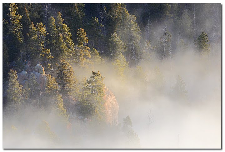
For my last morning shoot, I figured I'd try Castle Valley in hopes of getting a repeat performance of yesterday's fog (accessed from Highway-128 this time), but was out of luck. The air was bitter cold and very clear, so I decided to head back up 128 to start the trip home. Shortly after hitting the highway, with still about half an hour to go before sunrise, the dramatic silhouette of Fisher Towers presented itself, and a very thin crescent moon was not too far away. It then became a simple task of finding that point along the highway where the two lined up. It was a serendipitous way to start my final day, to say the least. In fact, the shots of the crescent moon rising over and amongst the towers turned out to be some of my favorite images from the trip. [photo]

I did find a little bit of fog along the Colorado River as I headed northeast, and took a few shots of it along the way. Once back in Grand Junction, I found a car wash and attempted to explicate the few hundred pounds of ice that had so caked the rear wheel wells of my truck that every time I hit the slightest bump, the truck bed would slam down hard on the rear tires. There was only about an inch of clearance between the ice and the tires! After burning through every quarter I had in the truck – 26 of 'em! — and still only making minor headway, I decided the ice was evil incarnate. I'm convinced that if Hell ever does freeze over, this was gonna be the ice that did it.